Discovering Hidden Gems: The Rock Trail to Lost Lake Adventure


The Hike: Before you start hiking, take a moment at the Cyrus Gates Overlook - you're standing just 120 feet below the highest point in Larrabee State Park. The westward views over Bellingham Bay and the San Juan Islands are spectacular and worth a photo stop.
The trail
starts by traversing Chuckanut Ridge through mature western hemlock
forest. Don't get too comfortable with the gentle beginning - you'll
soon encounter a series of wooden steps descending into a ravine. This
steep section quickly reveals why the trail is designated for hikers
only - no bikes or horses allowed!

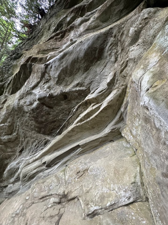


About a half-mile in, you'll encounter the trail's namesake feature:
impressive 100-foot sandstone cliffs.
While
hiking, you'll notice distinct 'steps' in the hillside formed by
alternating layers of hard and soft rock. The cliffs you see are made of
resistant sandstone, while the flatter sections between them are
composed of softer shales and thinner sandstone layers that have eroded
more easily over time. Though this area once supported tropical plants,
the sandstone along the Rock Trail is too coarse to preserve delicate
plant fossils, though you might spot the occasional piece of petrified
wood if you look carefully.
As you continue downward, you'll walk
among truck-sized boulders covered in licorice ferns. The forest canopy
opens up here, with bigleaf maples and red alders allowing sunlight to
reach the vibrant moss below. You will then cross Bogaard's Bridge
(named for the WTA crew leaders who helped build this trail).


.jpg)
Getting There from the south: Head north on I-5 for to exit 250. Turn left onto Old Fairhaven Parkway, which becomes Chuckanut Drive (SR-11). After about 7 miles, you'll reach Larrabee State Park. Turn right onto Cleator Road (expect some bumps and holes) and follow it up for 1.5 miles until you reach the Cyrus Gates Overlook parking lot. Don't forget your Discover Pass. You'll find vault toilets at the trailhead.
You have two options for your hike:
Continue to Lost Lake: After reaching the South Lost Lake Trail junction, it's just another mile to the peaceful north shore of the lake.
Make it a loop: You can create a longer adventure by connecting with other trails, but be prepared for some strenuous sections through dense vegetation. Be sure to download your map, because there are multiple connector trails you will encounter.
Trail Notes:
Distance: 2.2 miles round trip to the South Lost Lake Trail junction; add 2 miles for the lake visit
Elevation Gain: Approximately 1,000 feet
Difficulty: Moderate to strenuous due to steep sections
Best Season: Year-round, though winter can be slippery
Facilities: Vault toilets at trailhead
Fun Fact: This trail is a testament to community effort - over 100 volunteers contributed more than 2,000 hours to create this hiking gem, making it the newest addition to Larrabee State Park's trail system.
Whether you're a geology enthusiast, nature photographer, or just looking for a challenging day hike near Bellingham, the Rock Trail offers a unique perspective on the Pacific Northwest's natural history.


Comments
Post a Comment