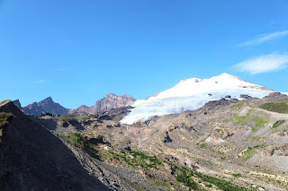
Railroad Grade Trail: Hiking to Incredible Views of Easton Glacier on Mount Baker
Click on a photo to enlarge it
The route to the summit of Mount Baker is not only a popular climbing path but also a spectacular summer hiking destination. The first 2.4 miles follow the Park Butte Trail, crossing Sulphur Creek and leading into Schreibers Meadow.
At around 2 miles, the trail emerges into another wildflower-filled meadow called Morovitz. After 2.4 miles, you'll reach the junction of Park Butte and Railroad Grade, where you'll turn right. Here you will ascend on stone steps, and follow the trail along some campsites.
At the 3-mile mark, you'll arrive at Railroad Grade, situated at the end of a glacial moraine. As you approach the mountain, you'll be greeted by the
sight of two distinct lateral moraines flanking the glacier – the
Metcaife Moraine on the left and Railroad Grade on the
right. These natural formations are a testament to the glacier's
powerful movement over time, carving and shaping the landscape with each
passing year. From here, you can peer over the steep edge and catch a glimpse of a waterfall and the glacier-fed creek below.
This might be a good turning point, or depending on the snow level, you may be able to hike further along the grade. At High Camp, located at 3.5 miles, the trail becomes a steep climber's path.
Prior to setting out on this hiking adventure, it is crucial to consult the weather forecast. Along the trail, hikers will encounter two water crossings. At the time of writing, one of these crossings has a bridge in place, while the other one requires hikers to ford the stream on foot. During hot weather conditions, the glacial waters tend to swell and run swiftly, potentially making the unbridged crossing more challenging and hazardous to navigate.
Logistics:
Restroom available at the start of the hike only.
Northwest Forest pass needed.
To reach the trailhead, take exit 230 off Interstate 5 in Burlington and head east on the North Cascades Highway (SR-20) for approximately 23 miles. After passing milepost 82, turn left onto Baker Lake Road. Continue along this road for 12.3 miles until you reach FR 12, which will be marked by a sign at the bridge before the road junction. Turn left onto FR 12 and follow it for 3.7 miles until you reach FR 13. At this point, take a right onto FR 13 and proceed for 5.3 miles until you arrive at the trailhead parking area. There are some potholes on the dirt road.
It's important to note that cellular reception and internet connectivity might be poor or unreliable in the hiking area, so it's advisable to download any necessary maps or directions beforehand. Additionally, it's recommended to inform others of your hiking plans and expected return time, as communication may be limited during your trek.


Comments
Post a Comment